
China’s Xiaokang Villages Along Arunachal Pradesh
What has changed over the last decade, what the infrastructure reveals, and what it could mean for India
China, the rising power
China, the rising superpower, the expert in the long game and the industrial hub of the second quarter of the 21st century, has become one of the defining subjects of global diplomacy and military affairs. The Communist nation that Russia aspired to be but could not, the mass exporter of everything from cheap plastics to expensive nuclear and electric vehicles, has built an industrial capacity that has few parallels.
The rise of China has once again contributed to the emergence of a bipolar world, with China and the United States occupying the two dominant positions in the international system. What made China evolve so rapidly over the last three decades is a subject in itself. One element, however, is difficult to miss: China’s sustained concentration on manufacturing and physical infrastructure.
Look at the Heihe–Tengchong line. This line divides China into two unequal parts. The eastern side hosts the overwhelming majority of China’s population because of its fertile plains, river valleys and the deltas of the Yellow and Yangtze rivers. If China wanted simply to diversify its population geographically, why would it look towards the Tibet Autonomous Region (TAR), a hostile, barren and extremely difficult environment in which to build infrastructure? If the objective were only to find additional land for settlement, there are other possibilities. The question, therefore, is not merely whether China is building in Tibet, but why it is willing to invest so heavily in some of the most difficult terrain on the planet.

The population-density map provides the geographic context for the argument. The stark contrast between the densely populated eastern half of China and the sparsely populated west makes the scale of infrastructure investment in the Tibetan region more interesting. The purpose of this study is not to claim that population settlement is the only reason for China’s infrastructure development. Rather, the contrast raises the central question of the analysis: what strategic utility does infrastructure in this difficult terrain provide?
Why Arunachal Pradesh matters
Arunachal Pradesh has been a major point of contention between India and China for decades. China continues to claim the territory as part of what it calls southern Tibet. The use of alternative names for places in Arunachal Pradesh and the history of Chinese positions on the territorial question reinforce the importance of examining physical developments on the other side of the frontier. The purpose of this analysis is not to revisit the territorial dispute itself. It is to examine what has physically changed in the border environment and what those changes could mean for India.
The Xiaokang village question
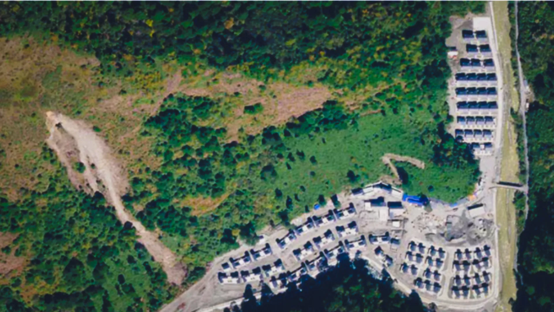
Over the last decade, China has built numerous villages along its border with India, commonly referred to as Xiaokang or ‘moderately well-off’ villages. Unofficial figures cited in the research place the number of such villages at approximately 600–628, with a large share located opposite Arunachal Pradesh. Those figures require independent verification and are therefore treated here as an indication of scale rather than as a definitive count.
The more interesting question is what these settlements actually represent. On paper, they can be described as civilian border villages. But a village cannot be understood only through the houses inside it. In difficult terrain, the road that reaches the village, the bridge that crosses the river, the logistics infrastructure that supports it and the air-access infrastructure in the wider area can be more important than the settlement itself.
This analysis therefore examines a sample of approximately 10–12 locations opposite Arunachal Pradesh, together with several additional comparison sites. The focus is on how these locations have evolved over roughly the last decade: the buildings that have appeared, the roads and bridges that have been developed, the relationship between settlements and the surrounding terrain, and the infrastructure that may increase the accessibility and permanence of these otherwise remote areas.

The selected locations are treated as a sample rather than a complete inventory. The red AR15 marker shown inside the Indian side is particularly important because it demonstrates the need for careful geolocation and boundary-reference verification throughout the study. All distance-to-border observations should be treated as approximate until the coordinates and reference boundary are independently checked.
What the satellite imagery is showing
The clearest way to understand the development is through time. The imagery does not simply show new buildings appearing in isolation. Across several locations, the pattern is one of increasing built-up density, improved access routes and the gradual transformation of previously sparse sites into more permanent settlements or infrastructure nodes.
The following site comparisons are therefore read as pieces of a larger story. Some sites have strong before-and-after evidence; others provide only a current-state view. Where the imagery does not support a firm conclusion, the assessment remains deliberately cautious.
AR 1Geling sector


The comparison of AR1 between 2019 and 2024 shows a clear change in the built environment. The later image contains a substantially more developed cluster of structures and a more clearly defined access route than the earlier image. The most important feature is not one individual building but the emergence of a coherent settlement footprint in terrain that offers little natural advantage for easy construction. The development indicates that the location has moved beyond a minimally or not occupied border site towards a more permanent infrastructure node.
The imagery supports a conclusion of significant physical expansion. It does not, by itself, establish whether every structure has a military function. The strategic relevance comes from the combination of permanence, access and location.
AR 2Brahmaputra / Yarlung Tsangpo


AR2 provides a useful example of development close to the Yarlung Tsangpo/Brahmaputra system. The earlier imagery shows a far less developed footprint, while the later imagery reveals a much more organised settlement and road pattern. The location on the river is significant because river crossings and road approaches are among the most important constraints on movement in this terrain.
The change suggests that infrastructure development is being accompanied by improved access to a geographically important corridor. The river itself is not merely a geographic feature but an obstacle that infrastructure can convert into a mobility advantage.
AR 4Rapid development


The AR4 comparison shows a dramatic transformation between the earlier and later imagery. The later image contains a more substantial built footprint, visible construction activity and a much more developed access arrangement. The scale of earthworks visible in the later image indicates that the change is not simply organic village growth; it represents deliberate construction activity.
The key analytical point is the speed of transformation. In a remote mountainous environment, the ability to execute large earthworks and establish permanent structures is itself an indicator of substantial logistical and engineering effort.
AR 5Settlement development


AR5 shows the development of a settlement in a narrow and difficult valley environment. The later image contains a substantially larger and more organised built-up area than the earlier image, with access routes converging on the settlement.
The pattern is consistent with an effort to create a permanent and accessible settlement rather than a temporary seasonal presence. The surrounding terrain makes the road connection particularly important: the settlement’s utility depends heavily on the ability to maintain reliable access.
AR 6Monigong sector

AR6 is identified as approximately 10 km from the Indian border opposite the Monigong sector. The image shows a developed site in steep and heavily forested terrain. The principal value of this location in the study is its proximity to the frontier and its position within a difficult access environment.
The exact distance might not be perfect. The location nevertheless illustrates the broader pattern of infrastructure being pushed into terrain where construction and year-round access are inherently difficult.
AR 7Settlement inside India?


AR7 is somewhat different. The settlement appears to be inside Indian borders. The site warrants verification because its apparent geographic location, infrastructure characteristics and connectivity raise the possibility of development inconsistent with the assumed boundary position. Exact coordinates and an authoritative boundary reference should be used to establish its territorial status before drawing any conclusion regarding Chinese construction or encroachment.
AR 8Gelimo sector


AR8 is described as a forward location opposite the Gelimo sector. The later imagery shows a more developed site and clearer access arrangement than the earlier image. The change is particularly useful for examining how a small forward position can evolve when supported by a wider infrastructure network.
The physical development is observable; the exact operational status or military function requires corroboration beyond imagery. The important GEOINT question is how the location connects to the surrounding roads, settlements and other infrastructure.
AR 9 / AR 12Possible logistics node


The AR9/AR12 imagery shows a substantially larger and more organised infrastructure footprint in the later period. Roads, structures and cleared areas form a more coherent node than in the earlier imagery. The scale of development makes this one of the more important sites for further analysis.
The location appears consistent with a logistics-support function, particularly because of its connectivity and built footprint. However, imagery alone cannot establish the exact purpose of individual buildings.
AR 10Tasking sector

AR10 provides one of the clearest examples of transformation across multiple stages. The imagery shows the evolution of the site from a limited footprint into a substantially more developed complex. The surrounding road network and extensive construction activity are as important as the buildings themselves.
The cumulative change suggests that infrastructure development is occurring at a system level: settlement construction is accompanied by access development and the creation of a larger support footprint. This makes AR10 particularly useful as a case study for understanding how isolated border locations can become integrated nodes.
AR 15 / AR 16Tawang sector


The AR15 and AR16 imagery shows substantial development in the Tawang-facing sector. The later images show denser construction and more developed access routes than the earlier terrain. The scale of the built footprint is notable given the surrounding high-altitude terrain.
These sites should be examined alongside their road connectivity and proximity to other infrastructure. The imagery supports the assessment that infrastructure development is not limited to isolated houses but is accompanied by significant site preparation and connectivity.
AR 17Geling sector


AR17 shows a current developed site in steep terrain, with visible structures and an access route. The available imagery provides a useful current-state view, although the temporal comparison is less complete than for some other sites.
The site should therefore be retained as a monitoring location rather than used as a major quantified before-and-after case until an additional historical image is incorporated.
Possible Indian-side settlement — Monigong sector

The image shows a settlement that is described as potentially lying on the Indian side opposite the Monigong sector. The location and territorial attribution require exact coordinate verification before any potential action from Indian side.
Looking at the Indian side
Looking at the Chinese-side infrastructure without examining the corresponding Indian infrastructure would produce an incomplete picture. The Bum La outpost provides a useful comparison because it illustrates the practical difficulty of maintaining infrastructure in the same high-altitude environment.


The imagery shows a relatively limited and rudimentary footprint compared with the more extensive infrastructure visible at several of the Chinese sites examined above. The comparison should not be interpreted as a direct measure of military capability, because operational capability depends on factors that satellite imagery cannot establish. It does, however, raise a straightforward infrastructure question: how effectively can India sustain personnel and mobility at these locations compared with the infrastructure now available on the Chinese side?
The village is only one part of the story
The strongest finding emerging from the imagery is that the Xiaokang villages should not be analysed as isolated settlements. The strategically important element is the infrastructure network around them. A village with poor access remains constrained by terrain. A village connected by an all-weather road, a bridge and a larger logistics node is a very different proposition.
The recurring pattern across the selected sites can therefore be viewed as a sequence: settlement development, road improvement, bridge construction or upgrading, connection to larger routes, and the creation of additional support infrastructure. The exact sequence varies by location, but the cumulative effect is a reduction in physical isolation.
Roads and bridges
Road connectivity deserves particular attention because roads determine whether the infrastructure can be used reliably. In mountainous terrain, the construction of a building without a dependable access route provides limited strategic value. Bridges are similarly important because they convert rivers and seasonal crossings from major constraints into predictable links in a road network.
Air access and forward mobility
Several of the broader areas examined also contain or are associated with helipads, airstrips or other aviation-related infrastructure. These facilities should be treated as a separate layer of analysis. Their presence can reduce the dependence of remote locations on road access, but imagery alone does not establish how frequently they are used, by whom, or for what purpose. The relevant analytical question is therefore how air-access infrastructure interacts with the road and settlement network.
How much infrastructure can these villages support?
The original research question also asks how many people could be accommodated. A precise figure cannot be responsibly derived from the available imagery without a defined building-counting and floor-area methodology. A more defensible first step is to quantify the number and approximate footprint of structures, classify visible building types where possible, and then derive a range of accommodation capacity using stated assumptions.
Civilian villages or something more?
The term ‘civilian village’ does not automatically answer the question of strategic function. The imagery shows that many of these sites contain residential-looking structures, but the wider infrastructure surrounding them matters. Roads, bridges, logistics areas and air-access facilities can serve civilian and security purposes simultaneously.
The most defensible conclusion from the current dataset is therefore not that every Xiaokang village is a military base. It is that the physical development of the settlements and their supporting infrastructure can create conditions that are useful for border administration, permanent habitation, logistics and potentially dual-use activity. Determining the precise military role of any particular site requires corroborating evidence.
What does this mean for India?
China’s advantage in this environment is not simply that it has constructed buildings close to the frontier. The more important issue is the cumulative improvement in accessibility and permanence. If previously difficult terrain becomes increasingly connected by roads, bridges, settlements and air-access facilities, the logistical constraints that once limited activity in the region are progressively reduced.
The implications for India therefore extend beyond the individual villages. A denser and better-connected infrastructure network can support more persistent habitation, improve movement and sustain activity closer to the frontier. It can also provide a foundation from which additional infrastructure can be developed later.
China’s geographic position also matters. The high-altitude terrain gives it an elevation advantage in several sectors, while its position upstream on the Yarlung Tsangpo/Brahmaputra introduces another strategic dimension. The construction of major water infrastructure in the Medog area is therefore relevant to the broader strategic context, although the technical characteristics and operational implications of such projects require separate research.
What should India do?
The first requirement is not simply to respond to individual Chinese villages. India needs to respond to the infrastructure system. That means improving the ability to connect, supply, monitor and sustain Indian positions in the same difficult environment.
Conclusion: the real story is the network
The imagery reviewed for this study points to a clear and important transformation along the Chinese side of the frontier opposite Arunachal Pradesh. Over approximately a decade, multiple locations have moved from sparse or limited development towards denser and more connected infrastructure.
The significance of the Xiaokang villages therefore lies less in the houses themselves and more in the infrastructure ecosystem developing around them. Roads, bridges, settlements, logistics areas and air-access infrastructure collectively reduce the physical isolation of remote border locations.
That is the central finding of this analysis: the strategic effect of the development should be evaluated as a network, not as a collection of villages. For India, the appropriate response is consequently also systemic — better connectivity, stronger logistics, persistent GEOINT monitoring, resilient forward infrastructure and continued diplomatic engagement.
This is an open-source GEOINT analysis based on the imagery and material assembled for the study. Several numerical claims in the initial research — such as the total number of Xiaokang villages and the proportion located opposite Arunachal Pradesh — are unofficial estimates and should be independently verified before publication. Similarly, exact distances from the LAC and territorial attribution of individual locations should be calculated from coordinates and a clearly identified boundary reference.
The analysis intentionally distinguishes between what the imagery shows and what can reasonably be inferred from it. Satellite imagery can demonstrate physical change; it cannot independently establish intent, command relationships or the precise operational purpose of every facility. Those questions require OSINT corroboration and, where possible, multiple independent sources.