By The Eastern Strategist | 15 July 2026
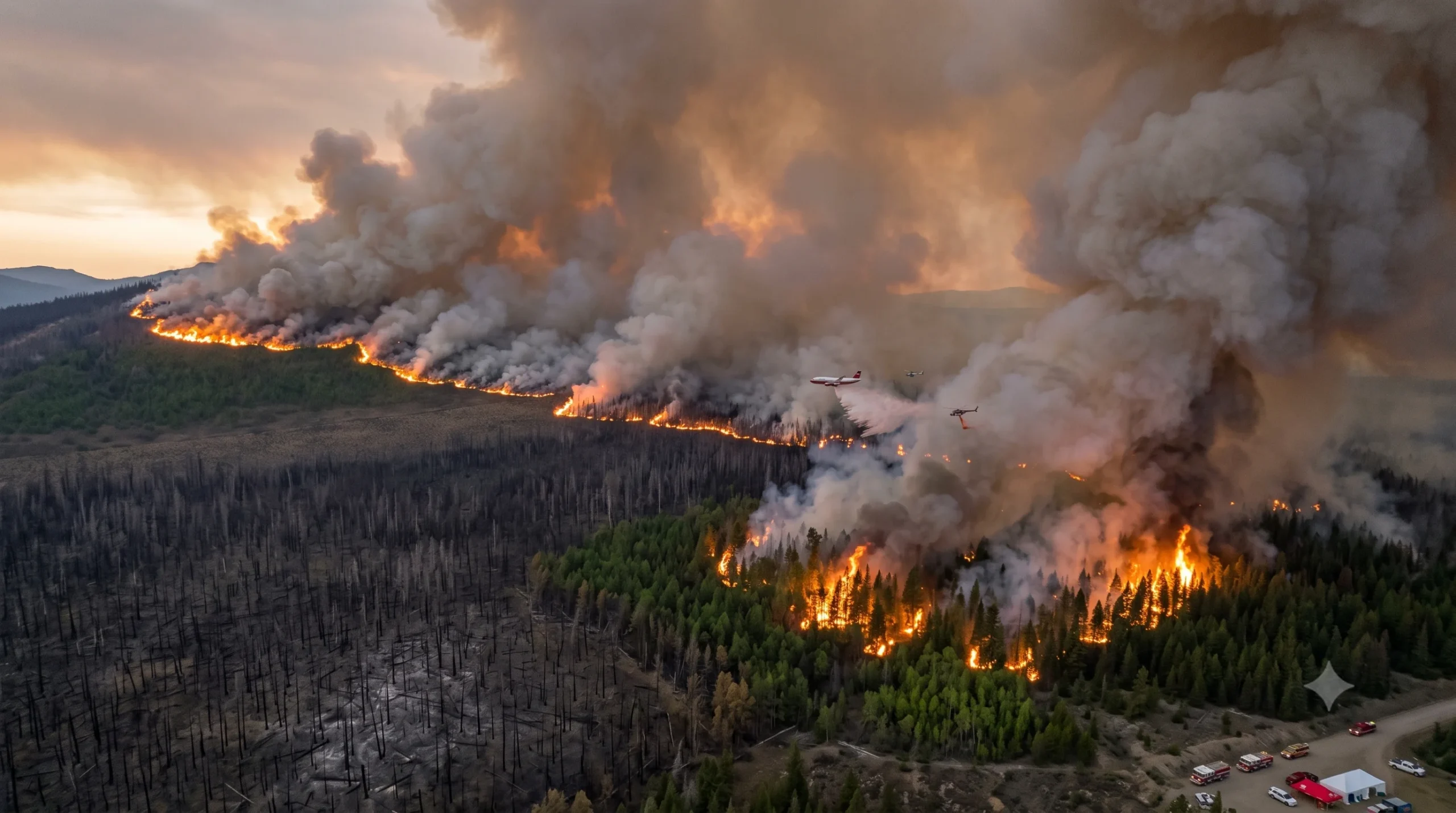
As part of the escalating Canada wildfires 2026 season, a fast-moving wildfire emergency in northwestern Ontario has forced mandatory evacuations of multiple communities, closed major highways, and sent a thick plume of smoke across the Great Lakes and into the northeastern United States, where cities from Boston to New York are experiencing hazardous air quality and orange-tinted skies this week.
The crisis is unfolding against the backdrop of a prolonged heat wave that pushed temperatures in parts of northwestern Ontario close to 40 degrees Celsius on Monday, creating conditions that fire managers described as extreme across the Thunder Bay, Dryden, Fort Frances, and Kenora districts.
What Is Happening on the Ground
Ontario’s Ministry of Natural Resources (MNR) reported 128 active wildland fires in the Northwest Region as of Monday evening, with 53 classified as not under control. Thirty-one new fires were discovered on 13 July alone.
Mandatory evacuation orders were issued for Armstrong, Whitesand First Nation, Collins First Nation (Namaygoosisagagun), Lac des Mille Lacs First Nation, Lac La Croix First Nation (Gakijiwanong Anishinaabe Nation), and Gull Bay First Nation (Kiashke Zaaging Anishinaabek). Residents displaced from those communities were directed to Thunder Bay, though accommodation in the city quickly filled to capacity. Gull Bay First Nation confirmed that no lodging remained available for its members in Thunder Bay, and community members were being flown south to Toronto by Wednesday morning.
Additional communities — including Ignace, Atikokan, Crystal Lake, and areas along Highway 633 — were placed on evacuation standby and told to prepare for possible orders.
Highway 11 was closed between Highways 633 and 623 east of Atikokan. Highway 527 was shut northbound near Gull Bay First Nation. Highway 599 was closed southbound between Highway 516 and Mishkeegogamang First Nation. The province also issued Notices to Airmen (NOTAMs) restricting civilian aircraft from airspace above two active fire zones, including the Fort Frances 14 fire near Byers Lake, which had grown to approximately 1,750 hectares and remained out of control.
Wabakimi Provincial Park has been closed until at least 20 July.
Effective Wednesday at 12:01 a.m. local time, the MNR implemented a Restricted Fire Zone across the entire Northwest Region, suspending all burning permits and banning open-air fires including campfires. Portable gas or propane stoves are still permitted.
The fires are disrupting more than communities and roads. The Nishnawbe Aski Nation (NAN) warned that blazes threatened power lines serving remote First Nations communities, raising concerns about additional health and safety risks in areas that were already vulnerable.
Why Is the Sun Orange? The Science of Wildfire Smoke
Across Boston, New York, and much of the northeastern United States, residents woke this week to an unmistakable haze — skies that shifted from milky white to a brown-orange tint, the smell of woodsmoke, and dimmed sunlight. The cause is wildfire smoke travelling more than 1,600 kilometres from Ontario and northern Minnesota through the upper atmosphere on jet stream winds.
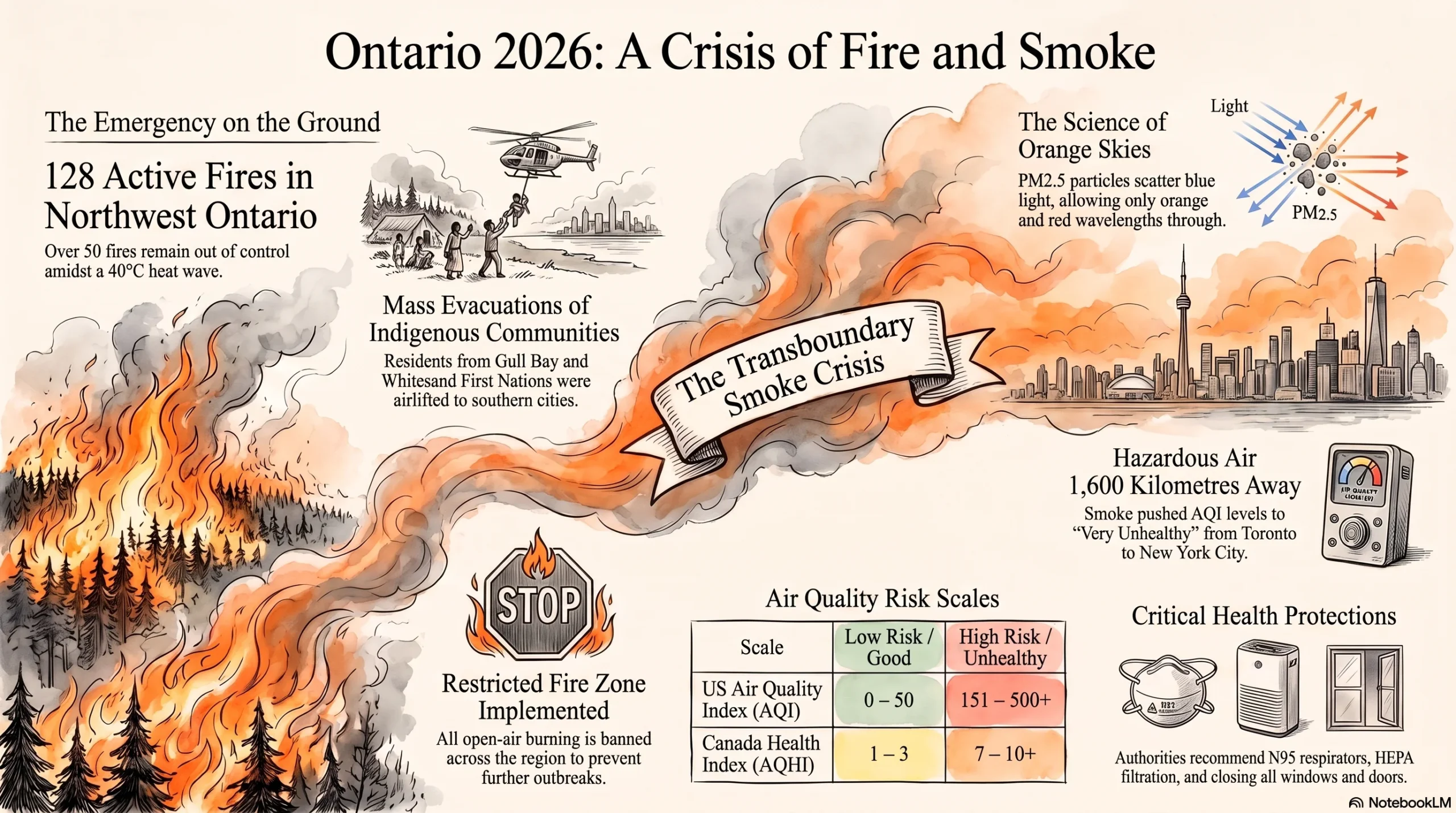
The optical effect results from the size of smoke particles. Wildfire smoke carries fine particulate matter, called PM2.5, which scatters shorter blue wavelengths of light while allowing longer orange and red wavelengths through — the same physics that produces vivid sunsets, compressed into the middle of the day.
The smoke plume that arrived over New England on Tuesday largely remained at altitude, limiting immediate ground-level air quality impacts. However, forecasters warned that a shift in the weather pattern through Wednesday and Thursday would bring denser concentrations of smoke down to the surface. The Fox Weather Centre warned of a six-to-eight-hour window in which smoke at ground level could cause visibility reductions and push air quality index (AQI) readings into the “very unhealthy” range in parts of the Upper Midwest. By Wednesday evening, heavy smoke was expected to have reached the Interstate 95 corridor from Buffalo to New York City and Philadelphia.
Boston’s AQI was already bordering on “unhealthy for sensitive groups” by Wednesday morning, according to the National Weather Service. Toronto ranked as the world’s second most polluted major city at 8:00 a.m. local time on 15 July, according to IQAir. Environment Canada had issued orange-level air quality warnings for the Greater Toronto Area and Kitchener-Waterloo, and yellow warnings for London and Sarnia. The Air Quality Health Index (AQHI) for those areas was forecast to peak above 10 — the high-risk threshold — through Thursday night.
Michigan was placed under a statewide air quality alert. Minnesota and Wisconsin also issued warnings. By Thursday, authorities forecast that some of the worst readings could be recorded from Duluth to Green Bay, with conditions in parts of the Upper Midwest potentially reaching dangerous levels for all residents, not only those with existing health conditions.
The situation carries echoes of June 2023, when Quebec wildfires turned New York City skies a deep orange. Meteorologists noted that while current conditions were expected to be less extreme than that episode in New York, comparable atmospheric smoke concentrations were possible in parts of the Midwest.
The Canada Wildfires 2026 Map: A National Picture
The Ontario outbreak is the most acute emergency within a broader national picture that, while below recent historic peaks, is intensifying as summer progresses.
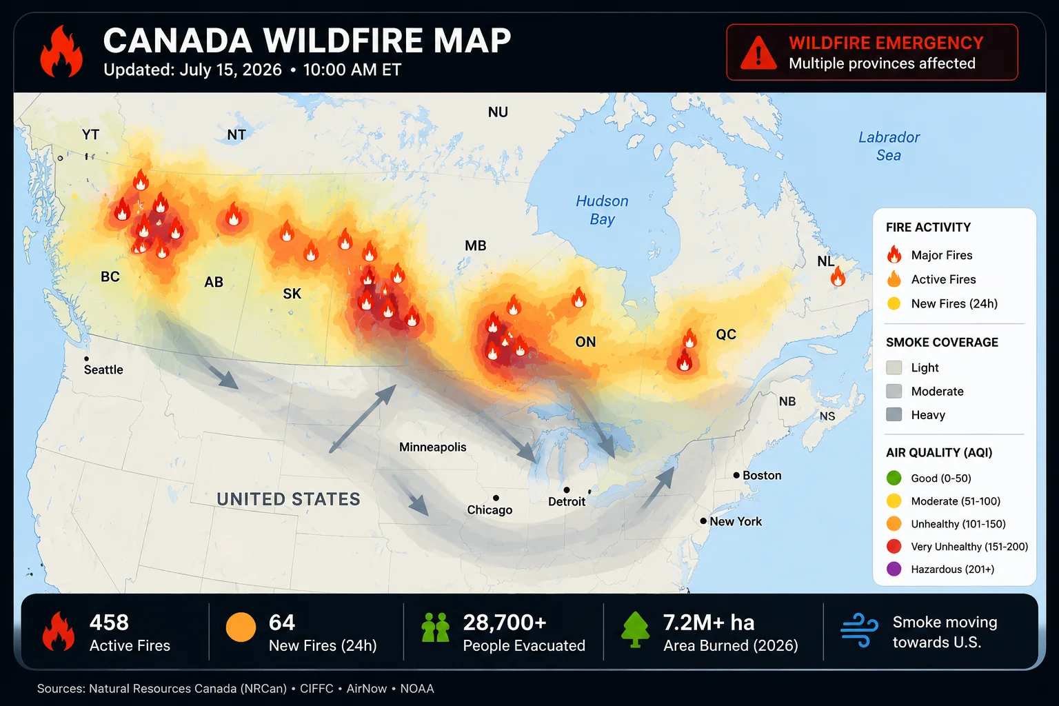
According to the Government of Canada’s July 2026 seasonal update, 3,137 fires had burned approximately 1.4 million hectares nationally by the start of this month. That is more fires than at the same point last year, when 2,913 had been recorded, though last year’s total area burned — nearly 4.6 million hectares — was significantly higher. The Canadian Interagency Forest Fire Centre (CIFFC) reported 836 active wildfires nationally as of this week, including 194 classified as completely out of control.
Significant activity is concentrated in the Northwest Territories, Ontario, and Quebec. Fires are also burning across northern Minnesota near the Canadian border, and some blazes have crossed the international boundary in both directions.
Environment and Climate Change Canada’s long-range forecast projects above-average temperatures across much of the country from July through August, with dry conditions expected to persist in Manitoba and northwestern Ontario. Fire danger in July is expected to remain highest in the Northwest Territories, Nunavut, northern Manitoba, and areas surrounding Hudson Bay, with elevated risk continuing in northern Ontario and Quebec.
Air Quality Index: What the Numbers Mean
For readers checking their local AQI or wildfire smoke map this week, a brief guide to what the numbers indicate:
The Air Quality Index, used in the United States, runs from 0 to 500. Readings of 0–50 are Good; 51–100 are Moderate. Above 100, the EPA categorises air as Unhealthy for Sensitive Groups; above 150 as Unhealthy for all; above 200 as Very Unhealthy; and above 300 as Hazardous. The Canadian AQHI uses a scale of 1–10+, where readings above 7 indicate high risk and above 10 indicate very high risk.
Health authorities advise that during smoke events, people keep windows and doors closed, run air purifiers with HEPA filtration if available, set HVAC systems to recirculate rather than draw in outside air, limit strenuous outdoor activity, and wear a properly fitted N95 or KN95 respirator when outdoors is unavoidable. Those at greatest risk include older adults, infants, pregnant individuals, people with asthma, and those with cardiovascular conditions.
Tracking tools for this event include: the Canadian Wildland Fire Information System (cwfis.cfs.nrcan.gc.ca), FireSmoke.ca for smoke dispersion modelling, the Ontario government’s interactive forest fire map at ontario.ca/forestfire, and IQAir’s real-time AQI data.
Camping and Outdoor Activity: What to Know
The Ontario government’s Restricted Fire Zone, now in effect across the Northwest Region, bans all open-air burning including campfires. Camping itself is not universally prohibited, but Wabakimi Provincial Park is closed to entry until 20 July, and conditions around Quetico Provincial Park remain under close watch.
Anyone planning camping, canoe trips, or other outdoor activity in northwestern Ontario should consult the province’s interactive fire map before travelling and monitor for evacuation orders or highway closures that could affect access routes. Several key highways remain closed as of this writing.
Climate Context
Scientists have noted for years that warmer temperatures, prolonged droughts, and shifting precipitation patterns were increasing wildfire risk and intensity across boreal forests. The current Ontario emergency — driven by a combination of record heat, low humidity, and strong winds — is consistent with that trend.
Canada’s worst wildfire season on record was 2023, when more than 18 million hectares burned nationally. Researchers have pointed to climate change as a driver of the conditions that make such seasons increasingly likely. The Government of Canada acknowledged in its July 2026 seasonal update that “climate change continues to drive more frequent and severe weather events,” while announcing a further CAD 1.25 million investment in wildfire preparedness projects, including programmes to train Indigenous wildland firefighters and integrate Indigenous knowledge into fire management.
What to Watch
The immediate priority over the next 48 to 72 hours is the trajectory of smoke affecting the Upper Midwest and Northeast United States. A weather pattern shift late this week is expected to begin dispersing the plume, but conditions in the most affected areas could worsen before they improve.
On the ground in Ontario, the key questions are whether evacuation orders will expand further and when the Fort Frances 14 fire and other active complexes can be brought under greater control. The Ministry of Natural Resources has indicated it does not expect fire hazard conditions to ease in the near term.
More broadly, with above-average temperatures and dry conditions forecast across much of Canada through August, the Ontario outbreak is unlikely to be the last significant event of the 2026 wildfire season. The door remains open for additional large fire events and further cross-border smoke episodes.
The Eastern Strategist will continue monitoring the 2026 Canada wildfire season. Readers are encouraged to consult official provincial and federal emergency management sources for real-time updates.