
Maritime Geopolitics · Analysis
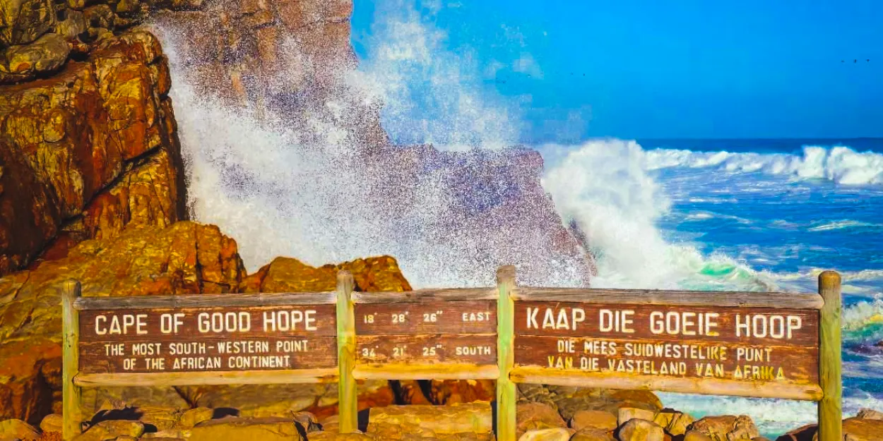
The wooden sign at the Cape of Good Hope is among the most photographed objects in Africa. Every day, travellers stand at the rocky shoreline of the Cape Peninsula, brace against the roaring wind, and mark what feels like the edge of the world. The geographers among them are usually wrong — the southernmost point of the continent belongs to Cape Agulhas, roughly 150 kilometres to the southeast — but the instinct is sound. Beyond the sign, where the warm Agulhas current of the Indian Ocean collides with the icy Benguela of the Atlantic, lies some of the most violent water on Earth.
Few of the visitors notice the ships. For most of the past three years, the horizon off the Cape of Good Hope has carried a near-constant procession of container vessels, tankers and bulk carriers — the detour fleet of a world that once again found the Red Sea too dangerous to cross. Between late 2023 and this month, the headland that Portuguese sailors called the Cape of Storms returned to its oldest job: the world’s plan B. A hesitant march back to the Suez Canal has now begun, but as this five-century story shows, the Cape of Good Hope never stays retired for long.
The Voyage Before the Legend
The Cape of Good Hope enters recorded history as a rumour. According to Herodotus, the Egyptian pharaoh Necho II dispatched a fleet crewed by Phoenicians around 600 BCE, ordering it to sail south from the Red Sea and return to Egypt through the Pillars of Hercules. The fleet was gone three years, putting ashore each autumn to sow and reap grain before sailing on. On their return, the crews reported something Herodotus refused to believe: sailing west along the southern end of Libya, they had the sun upon their right hand.
That detail is precisely what mariners in the southern hemisphere would observe — and it remains the strongest evidence that the voyage was real. It also vanished from the world’s working knowledge. Ptolemy’s geography, which shaped European understanding for over a millennium, treated Africa as an endless southern landmass that no ship could round. The question stayed closed until the fifteenth century, when Portugal’s search for a sea route to the spices of the East — past the Muslim-controlled overland networks — pushed caravels further down an unmapped coast.
Cape of Storms: Dias Names the Headland
Bartolomeu Dias left Lisbon in 1487, financed by King João II. His instructions, recorded by later chroniclers, included instructions to sail past the southern tip of Africa and attempt contact with Prester John, the mythical Christian king whose alliance was considered essential to breaking the Muslim monopoly on eastern trade. After touching the barren Namibian coast in December, the fleet met adverse winds and was driven offshore. In late January 1488, battered and land-blind, the expedition unwittingly rounded the Cape of Good Hope without seeing it.
The crews understood what had happened only when the coastline began trending northeast. They replenished water at a bay Dias named Golfo de São Bras — today’s Mossel Bay — where they bartered cattle and sheep with the Khoikhoi, and where an exchange later turned violent and Dias shot a man dead. On 12 March 1488, at a headland now called Kwaaihoek, Dias erected his furthest stone pillar, the padrão de São Gregório. Beyond it his exhausted crew refused to go. Frightened, short of provisions and facing mutiny, Dias turned for home.
From Cabo das Tormentas to Cabo da Boa Esperança
The naming happened not at sea but in Lisbon. The chronicler João de Barros records that Dias called the great headland Cabo das Tormentas — the Cape of Storms — and that on the expedition’s return, King João II renamed it Cabo da Boa Esperança, the Cape of Good Hope, in anticipation of the riches expected to flow from the Indies. It was a deliberate act of political framing. The first name described what sailors had endured; the second described what the crown now expected. One headland had been given two futures, and the king chose the profitable one.
There is a caveat worth stating plainly: Barros remains essentially the only source for the two-name story, and the historian Eric Axelson — who excavated the fragments of Dias’s padrão in 1938 — cast doubt on the legend, citing the account of the Portuguese chronicler Pacheco Pereira. The tradition is well established, but it is tradition. Dias himself never enjoyed the hope his king advertised. He drowned in May 1500 when a cyclone sank four ships of Cabral’s fleet in the South Atlantic — the discoverer of the route claimed by the ocean he opened.
The Graveyard of Ships and the Flying Dutchman
The Cape of Good Hope kept its side of the bargain. The meeting of the Agulhas and Benguela currents generates rogue waves, dense coastal fogs and gales that have claimed well over a hundred vessels, making the region a recognised graveyard of ships. From this record grew the sea’s most famous ghost story. Maritime folklore holds that Captain Hendrick van der Decken swore a blasphemous oath to round the Cape in a ferocious storm, condemning his vessel and crew to sail those waters for eternity — the Flying Dutchman, sighted since as a ghostly glow in the mist.
Folklore it remains. But the legend endured because the seas made it believable, and the psychology of the headland — the last great obstacle between a captain and the riches of the East — has changed remarkably little.
The Tavern of the Seas: The First Cape of Good Hope Boom
The first job of the Cape of Good Hope in the world economy was the one it holds again today: servicing ships forced to go the long way. On 25 March 1647, the Dutch East India Company ship Nieuwe Haerlem was wrecked in a storm in Table Bay. Sixty-two men stayed behind to guard the cargo and lived on the shore for about a year, bartering with the indigenous Khoikhoi. Their favourable report — the Remonstrantie of 1649 — persuaded the company to establish a permanent refreshment station for its fleets plying the Europe–Asia route.
Jan van Riebeeck landed at Table Bay on 6 April 1652 with three ships and instructions to build a fort, not a colony. The “Tavern of the Seas” that grew around it became Cape Town, and the provisioning stop became the gateway to European colonisation of the region — and to more than 150 years of Khoikhoi resistance to the seizure of their land. The pattern is worth noting. When the eastern trade route is blocked, the world’s shipping moves south, and a settlement rises to serve it.
1967–1975: The Last Time the Cape Ran World Trade
The Cape of Good Hope has carried the world’s trade around a closed Suez Canal before. After the Six-Day War of June 1967, Egypt shut the canal for eight years, trapping more than a dozen ships in the Great Bitter Lake as the “Yellow Fleet” while international traffic swung around the Cape of Good Hope. Freight rates surged, carriers imposed deviation surcharges, and the closure reshaped the industry for a generation: because sailing round the Cape made scale economics decisive, shipyards built the supertanker era — a 250,000-deadweight-tonne vessel rounding the Cape could carry oil more cheaply than a 75,000-tonner squeezing through Suez.
The economists’ verdict on that episode is sobering. A study of the 1967–75 closure found that trade between the worst-affected country pairs fell by over 20 per cent, took three to four years to adjust, and only recovered fully after the canal reopened. The distance between Mumbai and London, for instance, ran roughly 6,200 nautical miles through Suez and about 10,800 around the Cape of Good Hope. Chokepoint closures do not merely delay cargo; they redraw trade patterns, ship design and national economies for decades.

2023–2026: The Red Sea Crisis Puts the Cape Back on the Map
The modern rerun began on 19 November 2023, when Houthi forces seized the car carrier Galaxy Leader off Yemen. More than 100 merchant vessels have since been targeted in the campaign that followed, with four ships sunk, one seized and at least eight seafarers killed, according to industry tallies. Within months, the diversion around the Cape of Good Hope became systematic for the container majors.
The scale is documented in hard numbers. The International Monetary Fund’s PortWatch platform, tracking vessels’ GPS signals, recorded that traffic around the Cape of Good Hope more than tripled in three years: an average of 20 commercial vessels rounded it daily between March and April 2026, against six in the same period of 2023, while Bab al-Mandeb transits fell from 18 per day to five. Supply-chain consultants at Efeso estimated that roughly 70 per cent of the freight traffic that used the Red Sea in 2023 was being rerouted via the Cape of Good Hope. Drewry’s diversion tracker counted 181 containerships on the Cape route in the week ending 14 June 2026 — against 28 through the canal.
The Economics of Sailing South
The detour’s arithmetic explains why it could not last. Analysts at Upply calculate that Cape routing adds 17 days to voyages to Northern Europe and 25 days to the West Mediterranean, raising per-vessel costs by roughly 20 per cent — mostly fuel — and cutting a ship from about 4.2 voyages a year to 3.2. Consultancy Efeso’s supply-chain experts put the extra fuel burn at 30 to 50 per cent, with 10 to 20 per cent more ships needed to maintain the same service frequency.
| Route metric | Via Suez Canal | Via Cape of Good Hope |
|---|---|---|
| Mumbai–London distance (1967 study) | ~6,200 nautical miles | ~10,800 nautical miles |
| Added transit time, Asia–N. Europe | Baseline | +17 days (Upply) |
| Added transit time, Asia–W. Mediterranean | Baseline | +25 days (Upply) |
| Per-vessel cost | Baseline | ~+20%, mostly fuel |
| Voyages per vessel per year | ~4.2 | ~3.2 |
| Container ships observed (week to 14 June 2026, Drewry) | 28 | 181 |
The costs surfaced everywhere. Drewry’s World Container Index composite climbed 12 per cent in a single week in June 2026 to $3,969 per forty-foot container, its highest level in 18 months, while Cape diversions kept capacity tight. Maersk, the carrier that had staked its Gemini network on the detour, reported a $153 million loss in its Ocean division for the fourth quarter of 2025 — its first quarterly loss in years — and issued 2026 guidance stretching from a $1.5 billion loss to a $1.0 billion profit.
The pain was sharpest in Cairo. Suez Canal revenue fell from a record $10.25 billion in calendar 2023 to under $4 billion in 2024, a drop of more than 60 per cent, according to Suez Canal Authority figures. Recovery followed the partial return of traffic: revenue rose 23 per cent to $4.67 billion in the 2025/26 fiscal year, with 1,358 vessels transiting in August 2026 against 1,070 a year earlier. Both metrics remain far short of pre-crisis levels.
Bunkering Boom Along the Cape of Good Hope Route
Not everyone lost. The diversion turned the ports along the Cape of Good Hope route into the world’s fastest-growing refuelling market. Mauritius’s Port Louis sold a record 929,043 tonnes of bunker fuel in 2024, nearly double the 509,837 tonnes of the previous year, while the Cape Chamber of Commerce reported diversions rising 112 per cent by early March 2026. Namibia’s Walvis Bay and Luderitz attracted new physical suppliers, among them Dubai-based Flex Commodities, and trading houses including Vitol and Peninsula announced expansion plans. “Volumes have been positively impacted by the Red Sea security situation causing more vessels to reroute south of Africa,” a spokesperson for the supplier Monjasa told industry media.
South Africa captured less of the windfall than it might have. A PwC report found the country’s bunker volumes fell to about 80,000 tonnes a month in 2024 from about 130,000 in 2023, with business leaking to Port Louis and Walvis Bay after regulatory troubles hit the Algoa Bay refuelling point. For a state that sits on the Cape route itself, that is a strategy failure worth a column of its own.

September 2026: Back to Suez, Eyes Half-Open
This month, the pendulum swung again. Maersk and Hapag-Lloyd announced that four more services of their Gemini Cooperation — the AE5, AE11, AE12 and ME2 — would shift from the Cape of Good Hope back to the Red Sea and Suez Canal, joining the AE15 and AE19 services that had already returned. On 16 September, the 24,188-TEU OOCL Portugal made what the Suez Canal Authority described as COSCO’s first southbound container transit since the crisis began. The authority says services operated by CMA CGM, Maersk, MSC, Hapag-Lloyd and COSCO have all returned to the canal to varying degrees, with container net tonnage through the first eight months of 2026 up 54.2 per cent year-on-year.
The security backdrop, however, is moving in the opposite direction. In the same weeks, Houthi forces captured the port of Mocha and islands around the Bab el-Mandeb Strait, including Perim and the Hanish group — the narrow southern gateway through which every Suez-bound ship must pass. The group has so far limited its declared naval blockade to Saudi-linked vessels, and maritime analysts note that no container vessel has been attacked in the southern Red Sea for more than a year. Container carriers are gambling on that distinction holding.
Shippers’ representatives are not so sure. The Global Shippers Forum described the widening return to the Red Sea as a “reckless gamble,” citing continuing volatility and the demand for transparency about the intelligence underpinning carriers’ routing decisions. Their fear is timing: renewed attacks during the September–October peak season would force diversions mid-voyage, exactly the sort of whiplash that Xeneta’s analysts warned about when CMA CGM briefly reversed course — “unpredictability is toxic for supply chains.”
Insurance: The Geopolitics Meter
The clearest real-time read on the corridor’s risk is the war-risk premium. After Houthi missile and drone strikes on Saudi tankers in July 2026, indicative premiums for southern Red Sea voyages rose from around 0.3 per cent of hull value to above 1 per cent — with Saudi-linked sailings quoted as high as 3 per cent — and London’s Joint War Committee widened its high-risk zone to reach closer to the Saudi port of Jizan. Even small changes in these rates add hundreds of thousands of dollars to a single voyage. Marsh’s global head of marine warned of a “broken feedback loop”: fewer ships attempting the route leave underwriters less able to price the risk, which keeps rates high, which keeps ships away. Insurance, not just schedules, will decide whether the Cape of Good Hope detour truly ends.
The Cape of Good Hope as the System’s Pressure Valve
The return remains strikingly partial. Sea-Intelligence estimates that just over a quarter of Asia–Europe container capacity will transit the Red Sea in September, with about 35 per cent of westbound Asia–Mediterranean capacity using Suez. Xeneta’s data puts average weekly capacity through Bab al-Mandeb at roughly 213,000 TEUs in August 2026 — against more than 930,000 TEUs in August 2023. The gap between those two numbers is the Cape of Good Hope route.
Therein lies the collective-action problem. Each carrier has an incentive to return to Suez first — shorter transits, lower fuel, better schedules. Yet if all return, the released capacity collapses the freight rates that diversions currently support. Sea-Intelligence has modelled that a full return to Suez by the end of 2026 could reduce global headhaul TEU-mile demand by 8.7 per cent in the first half of 2027. BIMCO’s chief analyst warned late last year that freight rates could fall as much as 25 per cent in 2026 even with no change in the Red Sea. Expect carriers to manage the return as a supply valve, advancing it when rates weaken and retarding it when the surplus bites.
The India Angle: Operation Sankalp and the ME2
India sits on both sides of this story. When the crisis began, the Indian Navy renewed Operation Sankalp and mounted its largest deployment in the Gulf of Aden and western Arabian Sea since anti-piracy operations began in 2008. In the operation’s first hundred days, the Navy reported responding to 18 incidents, deploying over 5,000 personnel, more than 21 ships and 450 ship-days, saving over 110 lives including 45 Indian seafarers, and escorting 1.5 million tonnes of critical commodities. The destroyer INS Kolkata’s retaking of the hijacked bulk carrier MV Ruen in March 2024 — with marine commandos airdropped from an air force transport — ended with 35 pirates handed to Mumbai police for prosecution.
The commercial stakes are just as direct. The ME2 service now returning to Suez is the India–Europe route. For Indian exporters and importers, the choice between Suez and the Cape of Good Hope decides transit times, freight costs and supply-chain planning on one of the country’s most important trade lanes. New Delhi’s naval presence, meanwhile, has burnished its credentials as the resident security provider in the Indian Ocean — a role that outlasts any single crisis.
A World Heritage Headland on the Emergency Lane
There is an ecological postscript to this story of war-driven traffic. The Cape of Good Hope sits within Table Mountain National Park, part of the Cape Floral Region — a UNESCO World Heritage site that occupies less than 0.5 per cent of the African continent yet contains nearly 20 per cent of its flora, dominated by fire-adapted fynbos vegetation. Wild ostriches walk its white-sand beaches, Chacma baboons forage the cliffs, Cape mountain zebra and bontebok roam the hills, and southern right whales breach offshore in the winter months.
The Cape of Good Hope itself is now the standing emergency lane of world trade. A sanctuary that survived Dias, the Dutch and the supertanker era now hosts the detour fleet of a Red Sea war. The environmental stakes of routing the world’s merchant marine past a World Heritage coastline — from bunker spills to the longer route’s 20-odd per cent excess fuel burn and carbon footprint — have drawn remarkably little policy attention. They deserve more.
What Happens Next
Three scenarios frame the outlook.
First, a managed full return to Suez through 2027, releasing capacity and pressing rates downward — the scenario carrier shareholders fear and shippers await. Second, relapse: a single renewed attack on a container vessel in the southern Red Sea would likely send whole services back around the Cape of Good Hope overnight, reabsorbing capacity and spiking rates during peak season. Third, the longer game: with the Strait of Hormuz effectively shut amid the Iran conflict, oil exports that avoid Hormuz increasingly depend on Red Sea infrastructure — even as control of that sea’s southern gateway strengthens in Houthi hands. The two chokepoints are now one problem.
The Cape of Good Hope will stay on standby either way, exactly as it has since 1488. King João II understood something that today’s carriers and insurers are relearning: you can rename the danger, but you cannot rename the geography. The Cabo das Tormentas was there before the hope was, and it will still be there the next time the world’s shorter route fails.
Key Takeaways
- The Cape of Good Hope has served as the world’s alternative sea route for over five centuries — after Dias in 1488, for the Dutch “Tavern of the Seas,” during the 1967–75 Suez closure, and again through the 2023–26 Red Sea crisis.
- Cape of Good Hope traffic roughly tripled after November 2023, peaking near 20 vessels a day, while Suez revenue fell from $10.25 billion (2023) to under $4 billion (2024) before its partial 2026 recovery.
- The detour added 17–25 days and about 20 per cent to vessel costs on Asia–Europe voyages, keeping freight rates elevated and pushing Maersk’s Ocean division to a rare quarterly loss.
- The September 2026 return to Suez is partial and fragile: Houthi territory now rings the Bab el-Mandeb Strait, and war-risk premiums above 1 per cent of hull value show insurers remain unconvinced.
- India is directly exposed on both flanks — Operation Sankalp made the Indian Navy the region’s first responder, while the ME2 India–Europe service’s return to Suez restores shorter transit times for exporters.
Frequently Asked Questions
Why do ships go around the Cape of Good Hope?
Ships divert around the Cape of Good Hope when the Red Sea and Bab el-Mandeb Strait become too dangerous to transit — as they did after Houthi attacks on merchant vessels began in November 2023. The Cape route avoids the threat entirely, at the cost of 17–25 extra days and roughly 20 per cent higher vessel costs on Asia–Europe voyages.
Is the Cape of Good Hope the southernmost tip of Africa?
No. Cape Agulhas, about 150 kilometres to the southeast, is the continent’s southernmost point. The Cape of Good Hope is the south-western tip of the Cape Peninsula and marks the boundary where the Atlantic and Indian Ocean currents historically met for sailors rounding the continent.
How much longer is the Cape route than Suez?
On Asia–Europe voyages, sailing via the Cape of Good Hope adds about 17 days to Northern Europe and about 25 days to the West Mediterranean compared with the Suez Canal, according to analyst calculations. The 1967–75 closure study illustrates the distance: Mumbai–London runs roughly 6,200 nautical miles via Suez and about 10,800 via the Cape.
Is shipping returning to the Red Sea in 2026?
Partially and cautiously. Maersk and Hapag-Lloyd moved several Gemini services back to Suez from mid-2026, with container tonnage through the canal up 54 per cent year-on-year by August 2026 — but only about a quarter of Asia–Europe capacity was using the corridor in September, and the Cape of Good Hope route continues to absorb the rest.