
In April 2026 an Indonesian fisherman pulled a 3.7-metre, torpedo-shaped device from the sea north of Gili Trawangan, a small island in the Lombok Strait. Defence analysts soon identified it as a Chinese undersea sensor. The location is the story. The Lombok Strait is about 250 metres deep even at its shallowest point, deep enough for a submarine to cross between the Indian and Pacific oceans without surfacing.
That depth explains the Lombok Strait’s strategic importance. It lets the largest tankers bypass the shallow Strait of Malacca, gives allied submarines based in Australia a route north, and gives China a reason to listen. Indonesia owns both shores, yet the UN Convention on the Law of the Sea (UNCLOS) obliges it to keep the lane open to every flag, a regime Jakarta itself helped build.
The Indonesian Navy took the device to its Mataram base to establish its origin, purpose and stored data, according to ABC News. China’s foreign ministry said it had no specific details. Which Chinese entity deployed it, and why, has not been established.
The find came in a year when Hormuz and Bab el-Mandeb are being fought over with missiles, mines and blockades. Lombok’s contest is quieter and runs through law, depth and data. This explainer sets out what makes the strait distinct, what China, the United States, Australia and India each want from it, and what the Gulf crises have changed. TES tracks the wider theatre in its Indo-Pacific and China-Taiwan strategic hub.
In this explainer
- Why depth matters
- Lombok vs Malacca, Sunda and Ombai-Wetar
- Can Indonesia close it?
- China’s interest
- The US and Australia
- India’s role
- What the Gulf crises change
- What to watch
- The takeaway
- Common questions
What drives the Lombok Strait’s strategic importance?
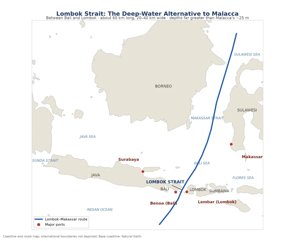
The Lombok Strait runs between Bali and Lombok and links the Bali Sea to the Indian Ocean. Its shallowest point, a sill between Nusa Penida and Lombok, is about 250 metres deep, and oceanographic studies put the northern basin at more than 1,000 metres. That depth admits submarines and the heaviest tankers, and the strait forms part of Indonesia’s Archipelagic Sea Lane II, known as ALKI II.
The Malacca Strait has no such margin. Its shallowest stretch near Singapore caps ships at a draught of roughly 20 metres, the shipping industry’s “Malaccamax” limit. The largest fully laden crude carriers exceed it, so the heaviest Gulf-to-East Asia cargoes swing south through Lombok and on through the Makassar Strait.
Width matters less, but it is not generous either. The Lombok Strait narrows to about 18 kilometres at its southern exit, according to ABC News and International Maritime Organization (IMO) records, and the IMO has designated the reefs of Nusa Penida and the Gili Matra islands as a Particularly Sensitive Sea Area.
Position does the rest. Lombok sits on the line between Australian waters and the South China Sea.
Lombok Strait submarines: why depth buys stealth
A submarine is most useful when nobody knows where it is. Malacca, shallow and crowded, offers almost no cover. Lombok allows a submerged crossing, and UNCLOS protects archipelagic sea lane passage in a vessel’s “normal mode”, which most naval powers read as permitting submarines to stay underwater.
Naval analyst H I Sutton argued in Forbes in 2020 that the Sunda Strait, though shorter, is very shallow at its eastern end, which makes Lombok the likelier choice for a submerged transit. The Manohar Parrikar Institute for Defence Studies and Analyses (MP-IDSA), an Indian think tank, counts four entry points for Chinese submarines into the Indian Ocean: Malacca, Lombok, Sunda and Ombai-Wetar.
How does Lombok compare with Malacca, Sunda and Ombai-Wetar?
Malacca is the busiest and shallowest route, Sunda the shortest but constrained at its eastern end, and Ombai-Wetar the deepest but the most remote. The Lombok Strait sits between them: deep enough for submarines and the largest tankers, and far closer than Ombai-Wetar to the main axis between the Indian Ocean and the South China Sea.
| Strait | Location | Depth, as reported | What it means |
|---|---|---|---|
| Lombok | Between Bali and Lombok; narrowest about 18 km | Sill about 250 m; northern basin above 1,000 m | Submerged transit; deep-draught tankers; on ALKI II |
| Sunda | Between Java and Sumatra | Very shallow at eastern end (Sutton, 2020) | Shortest route to the Indian Ocean; poor for submerged transit |
| Malacca | Between Sumatra and the Malay Peninsula | Draught limit about 20 m (“Malaccamax”) | Busiest route; root of China’s “Malacca dilemma” |
| Ombai-Wetar | North of Timor | Deep-water passage | On ALKI III; a long detour for most Indian Ocean–East Asia traffic |
Depth figures come from published oceanographic studies and news reports. TES has not consulted Indonesian hydrographic charts.
Why not Ombai-Wetar, then? It lies on ALKI III, far to the east. For most traffic between the western Indian Ocean and East Asia it adds distance, which is why, in TES’s assessment, Lombok carries the greater commercial and military weight.
Thailand’s proposed Kra Isthmus land bridge is a different answer to the same Malacca problem. TES has examined how that project could redraw the Malacca trade corridor. A land bridge moves containers, though, and submarines cannot use it, so the Lombok Strait’s military role stays intact.
Can Indonesia close the Lombok Strait?
Not by simple suspension. Under UNCLOS, archipelagic sea lane passage cannot be suspended. Article 53(7), however, lets an archipelagic state substitute other sea lanes “when circumstances require”, after due publicity, and Indonesia has designated only part of its lane system. Those two provisions are where the ambiguity lives.
Indonesia helped write these rules. On 13 December 1957 Prime Minister Djuanda Kartawidjaja declared the waters between the country’s islands to be Indonesian national waters, a claim UNCLOS recognised in 1982. The price of recognition was passage: Jakarta gained archipelagic waters, and the world gained guaranteed lanes through them.
Jakarta has tested the limits before. In 1988 it closed both the Sunda and Lombok straits for military exercises, and Canberra protested that the closure breached international law, Lowy Institute researcher Aristyo Rizka Darmawan recounts. In 1964, before UNCLOS existed, Indonesia refused the British carrier HMS Victorious passage through the Sunda Strait during its confrontation with Malaysia.
Darmawan also reports that a senior Indonesian Navy officer told him Indonesia may close a lane if necessary and offer a substitute, citing Article 53(7). Other legal experts argue the lanes must stay open as routes normally used for international navigation.
The convention’s text supports substitution, which requires publicity and referral of the new lane to the IMO under Article 53(9). In TES’s reading it does not support a unilateral shutdown.
Designation adds a second gap. Indonesia’s designated lanes run north to south, while the east–west lanes through the Java Sea remain undesignated, Darmawan notes. That difference decides whether a submarine may stay submerged or must surface and show its flag, a question that sharpens once AUKUS boats begin regular transits.
Money briefly entered the debate too. On 22 April 2026 then Finance Minister Purbaya Yudhi Sadewa floated a toll on ships using the Malacca Strait, citing Iran’s charges at Hormuz. Foreign Minister Sugiono said the next day that Indonesia was in no position to impose such charges, and Purbaya withdrew the idea on 24 April, saying Jakarta would uphold its UNCLOS commitments, according to ABC News and regional reporting.
The sensor raises a separate puzzle. Writing for the Lowy Institute, University of New South Wales researcher Dita Liliansa has asked whether an unmanned, unflagged object qualifies as a “ship” at all, and therefore whether it enjoys any navigation rights in Indonesian waters.
What does China want from the Lombok Strait?
A second door, and a way to listen. Commonly cited estimates put about 80 per cent of China’s crude imports through Malacca, the dependence Hu Jintao reportedly called the “Malacca dilemma” in 2003. The Lombok Strait is a longer but workable Malacca alternative for tankers, and a channel where Chinese submarines and drones could move or track others.
The device points to the second motive. H I Sutton identified it as a Deep-Sea Real-Time Transmission Mooring System developed by China’s 710 Research Institute, ABC News reported. It carried the logo of the China Shipbuilding Industry Corporation, now part of China State Shipbuilding Corporation (CSSC), and is designed to anchor to the seabed and relay sensor data, including acoustic readings, through surface buoys.
Collin Koh, a senior fellow at Singapore’s S Rajaratnam School of International Studies (RSIS), told the ABC the system was capable of undersea warfare tasks, while noting that its data also has civilian uses. He said it was the first moored sensor buoy he knew of in the region. Malcolm Davis of the Australian Strategic Policy Institute (ASPI) said his guess was that it had been placed to monitor submarines passing through the strait.
Beijing’s answer was that research equipment sometimes drifts into other states’ waters after malfunctions, and that the find needed no “excessive interpretation”. Indonesia’s defence ministry said it would not draw premature conclusions and would step up monitoring of national waters. Neither government has published findings, so TES treats the device’s purpose as an assessment.
There is precedent. In December 2020 fishermen near Selayar Island in South Sulawesi recovered a Chinese glider-type underwater drone. Koh told the ABC that despite clear evidence of its origin, that case eventually “went quiet”.
Why do the United States and Australia need Lombok open?
Their submarines have to get north. Under the AUKUS plan announced in March 2023, up to four US Virginia-class submarines and one British Astute-class submarine are due to rotate through HMAS Stirling near Perth from 2027 as Submarine Rotational Force-West (SRF-West). Their routes to the South China Sea run through or around the Indonesian archipelago, and Koh calls Lombok a critical route for allied forces based in Australia.
Australia’s exposure is commercial before it is naval. Darmawan reports that routes through and around Indonesia carry 83 per cent of Australia’s maritime imports and about 90 per cent of its exports.
Canberra and Jakarta signed the Australia–Indonesia Treaty on Common Security in February 2026. Darmawan sees its consultation mechanisms as the place to plan how the lanes stay open in a crisis.
Indonesia is also building leverage of its own. Research by the International Institute for Strategic Studies (IISS), cited by Darmawan, says Indonesia is developing anti-access capabilities, including naval mines and submarines, around “strategic funnels” in its waters. Lombok is one of the obvious funnels.
Where does India fit in the Lombok contest?
At a distance, and through partners. India does not patrol Lombok, and its Andaman and Nicobar bases face the Malacca exit, far to the north-west. New Delhi’s stake runs through maritime domain awareness shared with Indonesia and Australia, long-range patrol aircraft and data fusion at Gurugram. This section is TES analysis built on documented agreements and procurement.
During Prime Minister Narendra Modi’s state visit to Indonesia on 6 to 8 July 2026, the India–Indonesia joint statement welcomed cooperation on maritime domain awareness and coastal surveillance. It also backed the India–Indonesia–Australia trilateral, including on maritime domain awareness, which is New Delhi’s most direct line into the waters around Lombok.
The two sides extended their maritime safety and security memorandum, and an Indonesian liaison officer is to be posted at the Information Fusion Centre–Indian Ocean Region (IFC-IOR) in Gurugram, according to an explainer published by India’s World. President Prabowo Subianto welcomed India’s interest in developing Sabang port, but Sabang sits at the northern mouth of Malacca and the statement framed it in civilian terms.
Aircraft fill part of the distance. The Defence Acquisition Council (DAC) granted Acceptance of Necessity for six more P-8I maritime patrol aircraft on 12 February 2026, according to Naval News. They would join eight ordered in 2009 and four in 2016, taking the fleet to 18, but Cabinet Committee on Security (CCS) approval and a contract are still pending.
Range is the limit. Lombok lies about 3,400 kilometres from Port Blair by TES’s calculation, beyond the roughly 1,200-nautical-mile mission radius Livefist cites for the P-8I. Watching the Lombok approaches therefore depends on partner data and bases, the gap TES examined in its analysis of Australia’s Cocos Islands.
What do the Hormuz and Bab el-Mandeb crises change for Lombok?
They show what happens when a chokepoint has no ready substitute. Neither crisis has altered Lombok’s geography. Both have pushed governments, insurers and traders to price the day a second route is needed, which raises the Lombok Strait’s value as a Malacca alternative even though it remains a longer one.
Hormuz is recovering unevenly. Oil and petroleum-product flows averaged 13.1 million barrels a day in the week before 30 September, about 77 per cent of the 17.1 million that crossed before the Iran war began in late February 2026, according to Kpler data reported by Gulf News. The same report says tankers are increasingly switching off tracking signals, so visible transit counts understate the flow. TES has analysed the workarounds that keep those volumes moving.
Bab el-Mandeb is contested on land as well as at sea. Al Jazeera reported on 11 September 2026 that Houthi forces had seized the last towns on Yemen’s Red Sea coast and pushed onto islands in the strait, citing government sources and witnesses. Yemen’s government said on 13 September that it had recovered some ground near the strait. TES’s Bab el-Mandeb explainer covers the background.
Lombok Strait and the market angle
Brent crude stood at $107.84 a barrel on 16 September, Gulf News reported. In July, Janiv Shah of Rystad Energy told CNBC that some investors had grown “a little bit jittery” about the idea of tolls in Malacca. Purbaya, while still finance minister, also pitched expanded refuelling and ship services along the Sunda and Lombok routes.
The implications below are TES assessment. If Malacca were ever restricted, longer voyages via Lombok would tie up more tanker days per cargo, and freight rates and war-risk premiums would move first. Indonesian port and bunkering services along ALKI II would stand to gain.
For India the industrial effect is slower. Demand for anti-submarine aircraft, sonar and data links grows as more sea lanes need watching, but the P-8I purchase runs as a government-to-government deal under the Defence Acquisition Procedure 2020, which waives offset obligations and does not require co-production, according to Army Recognition. That limits the direct return to Indian industry from this particular buy.
What should readers watch next?
Five developments would show whether the Lombok Strait’s profile is rising. Each comes from a different capital, and only the 2027 submarine rotations carry a firm date.
- Indonesian findings on the sensor. A published result from the Mataram examination, or a formal protest to Beijing, would turn inference into evidence.
- Further device finds. Another moored sensor would strengthen the case that China is building a network across the archipelago’s sea lanes.
- Lane designation. Any move by Jakarta to designate east–west lanes would narrow the legal ambiguity Darmawan describes.
- SRF-West start. The first rotations through HMAS Stirling in 2027 would turn a plan into regular submarine traffic.
- India’s P-8I contract and the trilateral. A signed contract and a working India–Indonesia–Australia data-sharing arrangement would show how far India’s watching capacity reaches east.
The takeaway: Lombok matters for what lies beneath it
By chokepoint standards Lombok is wide, and for most ships Malacca remains the cheaper route. The Lombok Strait’s strategic importance lies below the surface: in the one channel where a submarine can cross between oceans unseen, and in a legal regime that Indonesia itself championed in 1957.
In 1988 Jakarta closed Lombok for military exercises, and Canberra protested. In 2026 the challenge arrived as a moored sensor on the seabed, with no flag, no crew and no admission of ownership. The country that helped write the rules for its waters now has to decide how much of that quieter contest it will tolerate inside them.
Common questions about the Lombok Strait
Why is the Lombok Strait strategically important?
Its depth, about 250 metres at the shallowest point, lets submarines cross submerged and carries tankers too deep for Malacca. It lies on the route between Australian waters and the South China Sea, and UNCLOS obliges Indonesia to keep it open.
Where is the Lombok Strait?
It lies between the Indonesian islands of Bali and Lombok and connects the Bali Sea to the Indian Ocean. It narrows to about 18 kilometres at its southern exit, near Nusa Penida.
Why do large tankers use the Lombok Strait?
The Malacca Strait limits ships to a draught of roughly 20 metres. The largest fully laden crude carriers exceed that, so they route through Lombok and the Makassar Strait to reach East Asia.
Can submarines pass through the Lombok Strait submerged?
Yes. Its depth allows submerged transit, and UNCLOS protects passage in a vessel’s normal mode within archipelagic sea lanes, which most naval powers read as allowing submarines to stay underwater.
Can Indonesia close the Lombok Strait?
UNCLOS bars suspension of archipelagic sea lane passage, but Article 53(7) allows an archipelagic state to substitute other lanes after due publicity. A senior Indonesian Navy officer has cited that provision; other experts argue the lanes must stay open.
Source transparency note
Verified or officially stated: the Indonesian Navy examination of the device (ABC News, citing Antara); the 12 February 2026 DAC approval for six P-8I aircraft (Ministry of Defence statement, reported by Naval News and others); the 6 to 8 July 2026 India–Indonesia joint statement; the April 2026 toll remarks and withdrawal; the UNCLOS text.
Third-party figures and analysis: depth and width figures (oceanographic studies, ABC News, IMO records); the device’s identification (H I Sutton via ABC News); Kpler flow estimates (Gulf News); Australia’s trade dependence and the 1988 closure (Lowy Institute); the Houthi advance (Al Jazeera, FDD’s Long War Journal).
TES analytical assessment: the purpose of the sensor; the reading of Articles 53 and 54 in a crisis; India’s role; the Port Blair distance calculation; the market and industrial implications.
This article is analysis, not investment advice.